What is It?
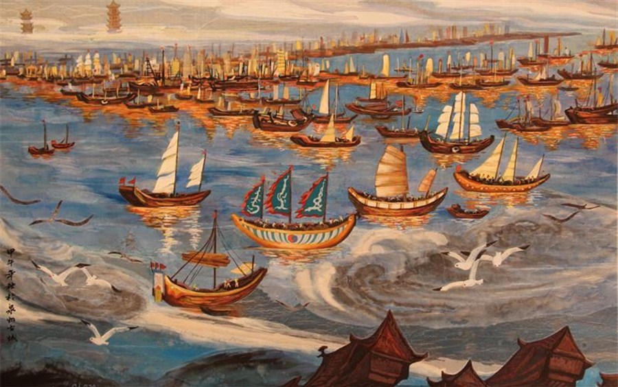
This painting depicts Quanzhou when it was major port city under the Yuan Dynasty. The painter and date of painting are unknown. In this painting, you see the vast amount of ships that docked and floated along the harbor. Each ship looks different, which means that they probably came from different areas. In the distance, you can see two pagodas, which are probably located in southern Quanzhou, where the foreign communities and Kaiyuan Temple are located. It looks like a great day in Quanzhou; the sea is calm, the wind is slowly guiding the ships, and the sun is setting.
Interesting Tidbit
One interesting tidbit of this painting is that it matches well with the observations made by Marco Polo about Quanzhou. Marco Polo wrote that when he visited Quanzhou there were vast amount of ships at the harbor. In this painting, the number of boats cannot be counted. I tried. This painting really illustrates how popular the harbor was in Quanzhou during this time period.
Connection to Guiding Question
This painting is example of how popular the trade city of Quanzhou was during the Song and Yuan dynasty. Merchants ships from every region came to Quanzhou to trade. There were small-size, medium-size, and huge-size merchant ships that arrived at Quanzhou. This painting demonstrates that Quanzhou was definitely a center of maritime trade and therefore, a city that gave Yuan dynasty a lot of revenue to pursue its military and political pursuits. In addition, this painting shows evidence of foreign communities in Quanzhou. In the distance, you can see the Twin Stone Pagodas of Kaiyuan Temple. These two pagodas carry non-Chinese religious carvings and are located in Quannan. Historians think Quannan was the area where the foreign communities resided and is located near the harbor.
Municipality of Quanzhou. (n.d.). Quanzhou [Illustration]. UNESCO. https://archive.shine.cn/newsimage/2017/03/08/020170308170944.jpg
 My Content Resources